Dashboard & checklists
Save Our Streams Inc. Command Center
Roya's Cabin
2,500 LF at Anderson Creek yielding **12,900 credits** ($2.32M Value). Fast-tracking regional permits.
Goldmine Hollow
Step-pool sediment traps on Noontootla Creek. Demonstrating wild trout bioengineering.
🚀 Hunter's Phased 90-Day Launch Plan
🛡️ Board of Directors & Governance
Hadi Irvani
Board MemberGeneral Partner at Infill Capital Partners, alumnus of the University of Virginia (UVA) and Harvard Business School (MBA). Oversees B2B real estate developer relationships, capital structuring, and strategic commercial scaling across the Southeast.
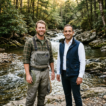
Hunter Morris
Co-Founder & Managing DirectorContact: bookings@flyfishingnorthgeorgia.com
Master guide and owner of Fly Fishing North Georgia with 15+ years of daily stream hydraulic and macroinvertebrate observation. A specialized fluvial geomorphologist who applies Natural Channel Design (NCD) and soil bioengineering to protect mountain land holdings and build pristine trout sanctuaries.
Joint B2B Operations Target
Hadi leverages his deep private equity and UVA developer network (including Transwestern and Fuqua) to secure bulk credit allocation contracts, while Hunter executes rapid Nationwide Permit 27 restorations yielding premium coldwater stream credits.
compensatory stream credit yield calculator
| Target Client Name | Category | Headquarters | Referral Advocate | B2B Sales Outreach |
|---|
Sourcing High-Priority Reaches in North Georgia
Mitigation banking and Permittee-Responsible Mitigation (PRM) rely entirely on localized hydrologic watersheds (HUC basins). The database below highlights **10 high-priority trout watersheds** in North Georgia suffering from severe sediment siltation, solar warming, or lateral bank erosion, presenting immediate sourcing opportunities for Hunter.
📁 Stream Restoration Strategic & Legal Library
Access all 17 strategic playbooks, regulatory mathematical models, case studies, databases, and sample landowner contract agreements compiled for Hunter’s venture. These documents are fully synchronized across **Markdown (.md)**, **Microsoft Word (.docx)**, and **Adobe PDF (.pdf)** formats in the local Google Drive folder.
📁 Enterprise Directory & Strategic Tiers
Filter all 82 strategic, technical, legal, and deep academic research assets by clicking a subdirectory within our core operational tiers:
Foundational Strategy & Corporate Governance
Environmental Engineering & Regulatory Science
Land Sourcing, Deal Flow & Capital Presales
Talent Pipeline & Brand Amplification
📝 On-Site Digital Contract Signer
Review the legally binding Joint Venture Cooperative Agreement below with the landowner (ACR 1910 LLC, managed by Roya Irvani). Both parties can sign directly in the browser using a stylus, finger, or mouse. Signatures are bound to the record in accordance with the Georgia UETA (O.C.G.A. § 10-12-1 et seq.) for instant execution.
STREAM MITIGATION BANKING AND JOINT VENTURE COOPERATIVE AGREEMENT
PROJECT: ROYA'S CABIN AT ANDERSON CREEK (ACR)
This agreement is made effective as of May 30, 2026, by and between ACR 1910 LLC ("Landowner"), a Georgia limited liability company managed by Roya Irvani, and Save Our Streams Inc. ("Developer"), managed by Managing Director Hunter Morris and Board Member Hadi Irvani (alumnus of the University of Virginia - UVA).
SECTION 1: THE 70/30 CREDIT SPLIT MODEL
The Developer shall receive **70%** of all Stream Mitigation Credits generated and released by the USACE Savannah District. The Landowner shall receive **30%** of all Stream Mitigation Credits generated and released. Gross proceeds from credit sales shall be paid directly from a secure escrow account to the parties in accordance with this 70/30 split ratio.
SECTION 2: QUANTITATIVE SITE ECONOMICS
* Total Stream Reach: 1,500 Linear Feet.
* SOP Yield Factor: 8.6 credits per Linear Foot.
* Total Credits Yielded: 12,900 credits.
* Market Credit Price: $180.00/credit.
* Gross Value: $2,322,000.00.
* Landowner pure risk-free gross allocation (30%): $696,600.00.
* Developer gross allocation (70%): $1,625,400.00.
* Developer construction and permitting CapEx covered (100%): $1,090,000.00 (Design, heavy earthworks, plantings, $220k performance bonds, 5-year monitoring, and endowments fully funded by Developer).
SECTION 3: CONSERVATION EASEMENT
The Landowner covenants to grant and record a perpetual restrictive Conservation Easement over the approximately 6.8-acre stream buffer corridor to an approved qualified third-party Land Trust. The Developer shall fund the required $90,000.00 Long-Term Stewardship Endowment trust.
SECTION 4: GOVERNING LAW AND ARBITRATION
This agreement shall be governed by the laws of the State of Georgia. Any disputes shall be resolved via binding arbitration administered by the American Arbitration Association (AAA) in Atlanta, Georgia.
IN WITNESS WHEREOF, the Parties have executed this cooperative agreement as of the date first written above.
ACR 1910 LLC — Roya Irvani, Authorized Manager (Landowner)
Hunter Morris (Developer)
🎬 Fluvial Bioengineering Visualizations & Drone creek Simulation
Explore the scientific, financial, and regulatory frameworks of Save Our Streams Inc. through interactive media. Review our three detailed, isometric-style graphics below, and experience our real-time HTML5 Drone Creek Survey Simulator to witness how geomorphic bank restoration and Rhododendron maximum transplanting recover coldwater trout populations.
🎬 Landowner Cinematic Video Playbooks & Aspirational Storytelling
Review the high-production, narrative-driven landowner videos synthesized for Managing Director Hunter Morris's high-ticket stream sourcing campaigns in North Georgia. These videos establish Hunter's geomorphic restoration expertise ("natural stream keeper" vs. nameless corporate clear-cutting) and illustrate the win-win joint-venture landowner model.
Video 1: The Geomorphic Spawning Hook
A high-velocity visual hook capturing vertical bank erosion and introducing the zero out-of-pocket geomorphic stream walk to North Georgia trout landowners.
Video 2: "The Trout Guide's Legacy"
A premium cinematic narrative tracking Hunter's personal background, contrasting bioengineering against concrete rip-rap, and detailing the 30% JV landowner split.
Internal Operations Schematic
Visualizes Rosgen Natural Channel Design geomorphic adjustments. Restores the historical high-gradient riffle-pool sequence and utilizes root-anchored vegetation to bind the stream bank.
- Fibrous Rhododendron maximum root-balls reinforce lateral soil shear.
- Evergreen thermal canopy intercepts solar radiation, suppressing peak heat.
- Instream geomorphic log cross-vanes scour deep coldwater trout resting pools.
Landowner JV Economics Infographic
Maps the 70/30 Joint Venture split for Roya's Cabin (Anderson Creek). Illustrates developer CapEx coverage, landowner credit returns, and long-term financial streams.
- Landowner bears zero monetary liability or upfront engineering cash outlays.
- Developer fully funds the $220k USACE Performance Bond & $90k LTM Trust.
- Credit payouts are automatically executed directly from secure B2B closing escrows.
CWA Compliance Offsets Diagram
Illustrates the Clean Water Act compliance workflow linking Georgia’s hyperscale data center grading impacts directly with Hunter Morris’s PRM restoration sites.
- Bypasses mitigation bank registry queues, accelerating campus grading timelines.
- Direct watershed-matching prevents off-basin regulatory credit multiplier penalties.
- Fulfills corporate ESG directives by restoring native wild trout coldwater habitats locally.